

HOGG AGM + How Marie Tharp and Bruce Heezen Created Some of the Most Popular and Influential Maps of the Ocean Floor
HOGG AGM + How Marie Tharp and Bruce Heezen Created Some of the Most Popular and Influential Maps of the Ocean Floor
Share this event
Need help?
HOGG AGM - followed by online talk with James Cheshire (Professor in Geographic Information and Cartography, UCL Department of Geography).
The AGM will commence at 13.00hrs (U.K. time) and the talk will begin at 13.30hrs.
Non-members of HOGG and guests are very welcome to join for the AGM, but will not be able to participate or vote on items and matters arising.
Mapping the Ocean Floor: How Marie Tharp and Bruce Heezen Create Some of the Most Popular and Influential Maps of the Twentieth Century
If you have ever encountered a map of the ocean floor, there's a good chance it was created, or at least inspired by, Marie Tharp and Bruce Heezen. Throughout the 1950s, 60s and 70s they compiled bathymetric data from research cruises and transformed maps of the seabed. Such maps went from showing it to be flat and featureless to depicting a complex terrain of rugged mountain peaks and valleys. Their maps caused a sensation and were published in their millions by the likes of Life Magazine, Fortune Magazine, and most famously National Geographic Magazine. Whilst beautiful in their execution, they had an underlying scientific motivation, and it is Tharp who is credited for being one of the first to notice a rift valley running down the centre of the Mid-Atlantic Ridge.
Based on research for the book The Library of Lost Maps, this talk will tell the story of how these maps came to be and share insights of Tharp and Heezen’s collaborations with the leading cartographers and illustrators of their era. The presentation will be richly illustrated with the maps themselves and from research conducted at the Library of Congress.
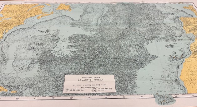
1957 Heezen-Tharp Map - one of the first published maps. Photo credit: © James Cheshire Collection